
A short while ago (the summer of 2020), the Bent Archive received a most helpful communication from Matthias Nöth, pointing out anomalies in the Google map we had plotted showing the itinerary Theodore and Mabel Bent had taken in 1888 when exploring areas of the western coast of Turkey, as far down as the (now Greek) island of Kastellorizo.
Realizing Matthias had a much deeper knowledge of the region than we did, we asked him if he would care to write for us a short illustrated sketch, a Bent-tour if you like, just referring to some of the sites the couple visited, perhaps from a modern archaeological perspective, something that dedicated travellers to those, still unspoiled, spots would enjoy.
And so, without further ado, we hand you over to Matthias (who shares his Christian name, incidentally, with the Bents long-term assistant from Anafi, who was with the couple on their slow cruise down this delightful extent of the Outer Levant — Matthias, the floor is yours:-
Between 1882 and 1898, Theodore and Mabel Bent made a total of seven trips that took them along the Greek and Turkish coasts. Mabel had kept diaries of all these trips. In these, the couple’s sixth voyage, or thereabouts, which took place in 1888 note 1 , we learn that the Bents – after a short stay on Symi – anchored in the bay of “Aplotheka” on the night of 10th March to the 11th.
They decided on this bay, which Mabel describes as having a “very deep, slope to the water in most places, but there are several little beaches of sand where landing is easy”, as there one may find “the ruins of ancient Loryma”. On one of these beaches there are “the remains of some large building and another a mandhra, or sheep fold. The wall of the yard runs along the shore and the family live in a little hut of rough stones, that one can see through, about 12ft. x 10ft. No window or chimney, fire on the earth in one corner, a few sticks stuck between the stones to hang things on and a shelf made with a pole across the end of the room and some branches on it. It is about 3 feet 6 inches wide and may be the bedroom, but we saw very few bedclothes or possessions of any kind, and yet the people seemed clean in their persons and certainly provide us with excellent cream and milk.”.
About her stay in the bay, we learn from Mabel that her husband Theodore undertook “a walk in the morning with Vassilis […] and Ioannis” on March 11th, while she stayed on board their ship. In the afternoon she roamed the bay with her husband and “choose a digging place for the morrow”. For March 12th, she reports that they were excavating “quite unmolested at large tombs, all with altars on them, but vainly”. Unfortunately, as with Theodore’s article in the Journal of Hellenic Studies (Vol. 9, 1888), Mabel’s chronicles are not very meaningful from an archaeological point of view. Presumably he does not elaborate on the ruins there as they were presented by O. Benndorf and G. Niemann four years earlier in their Reisen in Lykien und Karien (Vienna 1884) note 2 .

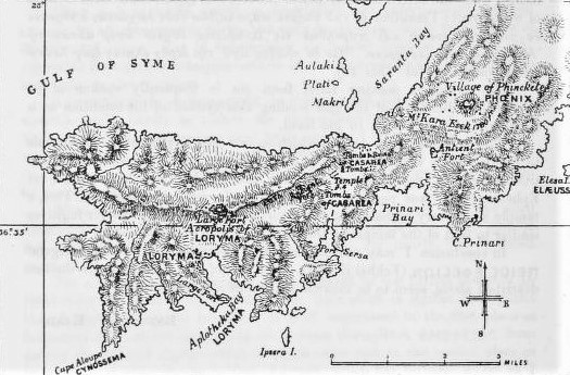
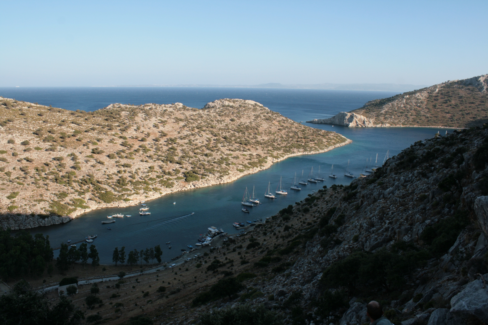
“Aplotheka” bay is known today as Bozukkale or Loryma Bay (Fig. 1), located on the southwestern edge of the Bozburun peninsula. This was known in antiquity as the Carian Chersonese and later belonged to the Rhodian Peraia. The bay itself can only be reached by boat or by taking a long walk overland. Despite, or perhaps because of, its remote location, it is a popular destination for sailing tourists, and since the opening of the Carian Trail also for hiking tourists. There are three seasonal restaurants in the bay and apart from these there are only two or three huts inhabited by shepherds.
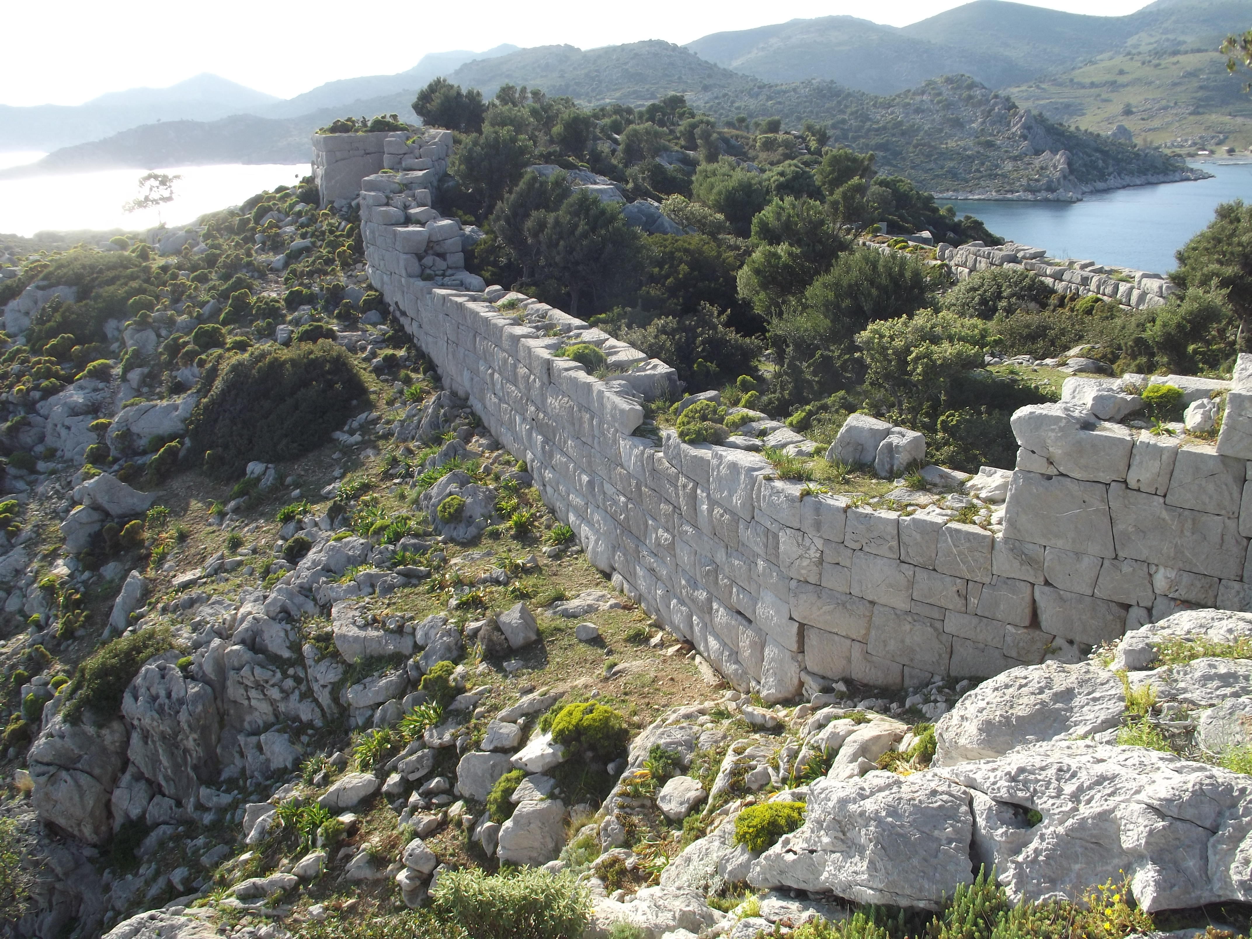
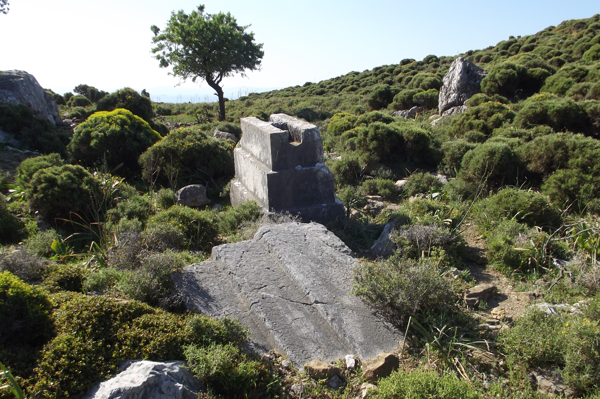
Thus little has changed since the Bents stayed there. The “remains of some large building” mentioned by Mabel have also been preserved. These could be the remains of a large building, probably built from spolia in Byzantine times, which may be seen in connection with an Amalfi trading post [Αποθήκη = warehouse ?]. It was built on the site where there were five ship sheds in antiquity (Fig. 1, right of the rocks in the foreground). The “ruins of ancient Loryma” include the large Rhodian harbour fortress (Fig. 2), the scant remains of two temples, the Loryma settlement, numerous ancient farmsteads, and the extensive settlement necropolis in which Mabel and Theodore apparently carried out excavations. The “altars” on the graves mentioned by Mabel are the grave top parts typical of the Carian Chersonese, in the form of monolithic or composite stepped bases (in English also referred to as “stepped pyramids”) (Fig. 3).
On March 13th, the Bents, accompanied by a shepherd serving as a guide, went eastwards to “a little harbor called Sigás and then walked to the sea on the other side of the promontory called Sikies (fig tree)” (= north coast). However, the excursion was, in Mabel’s words “disappointing”, probably because they did not make the hoped-for discoveries.
The port “Sigás”, which – according to the memoranda of Theodore published by E. L. Hicks (JHS 10, 1889) – was also called “Sersa” in Bent’s time, and is a bay now known as Serçe Limanı (Fig. 4). In ancient times it was called Κρήσα λιμήν or “portus Cressa”. Although the entrance to the “curiously hidden” bay is quite narrow – as Theodore wrote in his article – it was apparently a popular anchorage over the ages; this is shown by the five shipwrecks found there that date from the 3rd century BC to early 11th century AD.
In addition to Mabel’s chronicle entry, we learn from Theodore’s article that, after “about an hour’s walk”, there are extensive ruins in “a basin”. According to Theodore’s memoranda, he found there “covered by the ruins of a Byzantine church”, “a row of bases of columns (apparently in situ), as if a temple had stood here”, as well as numerous graves and a few inscriptions. According to one of these inscriptions, the temple was dedicated to Apollo. Three more inscriptions are featured in Hick’s article. In the north of the valley Theodore’s memoranda mentions “tombs composed of blocks of marble piled pyramid-wise upon each other”.
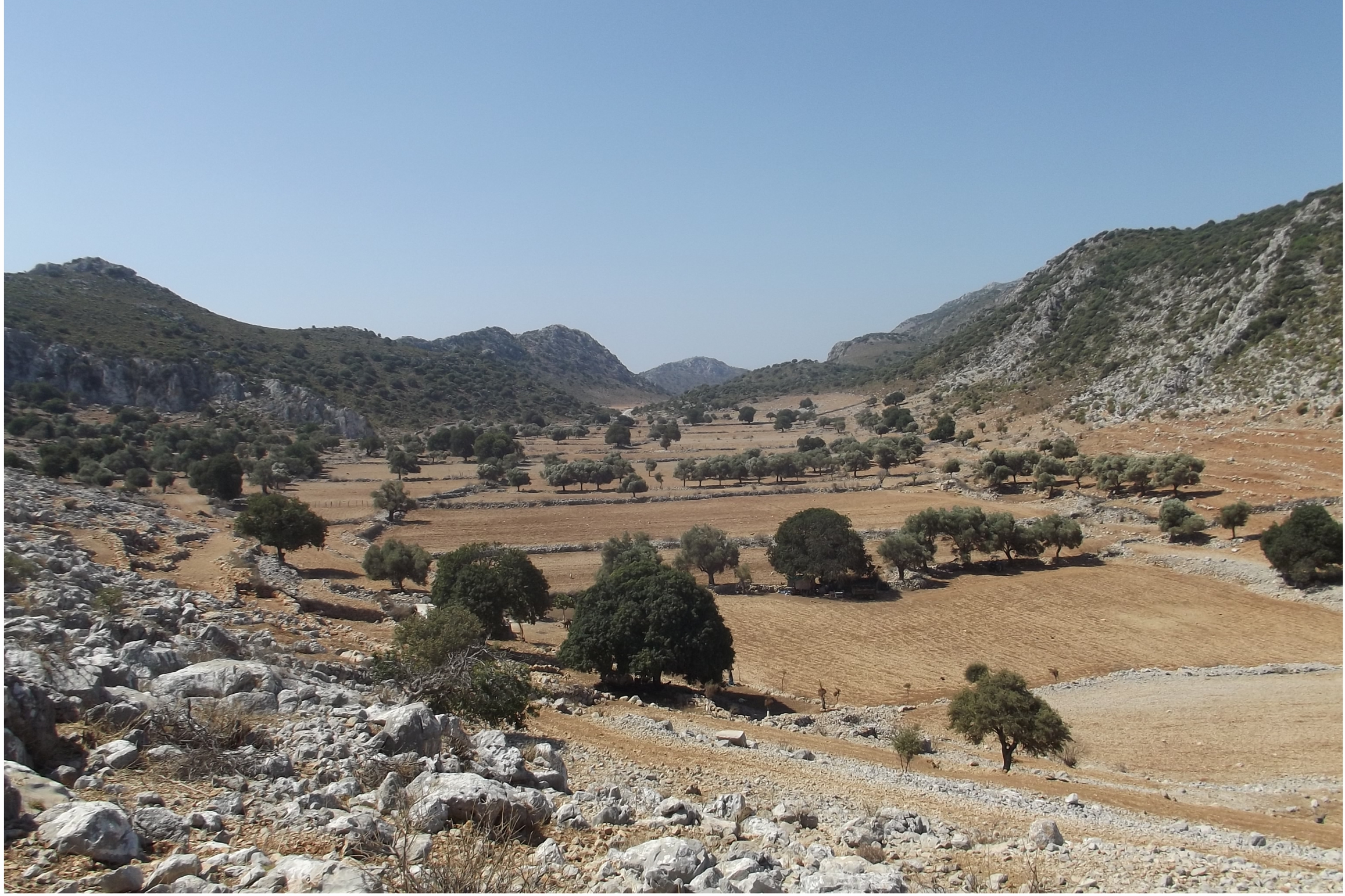
The “basin” is the valley that adjoins Serçe Limanı to the north and is known today as Asardibi; ancient Kasara is also located there. Today only a few ruins have survived in this valley (Fig. 5). The alleged temple remains were apparently not found in the recent survey, as they are not mentioned in the relevant publications. The ruins visible today are mainly graves with the grave top parts of the form known from Loryma, as well as some ancient farmsteads and the remains of associated agricultural terraces. In the far north of the valley, on a prominent hill, are the sparse remains of a small Byzantine settlement or fortress. However, between the Byzantine walls there are also remains of more ancient ones, so that one might possibly look for the acropolis of ancient Kasara on that hill. A few years ago, at the western foot of the hill, you could still see the graves discovered by the Bents; however, illegal construction work has taken place there, which has destroyed a large part of the historical substance.
Apparently Mabel and Theodore visited another ancient site on their trip to Kasara, i.e. locating Phoenix “about an hour’s walk [in an] eastward direction”. Since Theodore only mentions it briefly in his article (“… the modern village of Phoenike […] is built on the site of the old town …”), it will not be discussed further here. However, Phoenix and other ruins in the area are shown on the map created by Theodore for Hicks’ article. From an archaeological point of view, this map is also the most interesting result of the Bents’ stay on the Carian Chersonese, as some of the ancient ruins recorded there by Theodore are still almost unexplored.
About Matthias Nöth
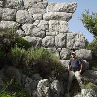
After doing his Magister Artium in Classical Archaeology at the University of Würzburg, Matthias completed an archaeological traineeship at the Archäologisches Spessartprojekt (with a focus on Medieval archaeology). He then went on to read for a Doctorate in Classical Archaeology at the University of Marburg, graduating in 2015. His dissertation on the Fortifications of the Carian Chersonese is currently in press. For his bibliography, see here.
During his studies, and as a volunteer, Matthias took part in several excavations in Bavaria, before he participated in survey projects in Turkey: at “Loryma” (2000) and “Bybassos and Kastabos” (2006-2011, 2015), both of which are on the Carian Chersones, today the Marmaris/Muğla region. After several round trips and hikes in the area, Matthias now knows the Carian Chersonese very well.
Return from Note 1
Return from Note 2
For more on the Bents along the Eastern Mediterranean coasts, see Further Travels Among the Insular Greeks (Archaeopress, Oxford)
 Leave a comment or contact us about this article